Barcelonette in the High Alps
Barcelonette in the middle of this map is a great place for cycling.

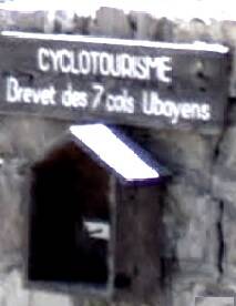
Participate in the Brevet des 7 cols , collect the free card at the Tourist Office. There is a marking machine on the cols.
On the map all roads look the same, but they aren't. Above Barcelonette we see climb number 3, to the ski-resort Sainte-Anne. This is where the paved road ends at 1830m altitude. There was a cobbled road which is shown on the map, going to Crévoux via the Tunnel du Parpaillon at 2650m. This tunnel is 540m long and leading to in the valley of the Durance. From that side the French artillery could be supplied that guarded the pass. Most of the cobbled road has been washed away by landslides and rain. The 4X4 cars and MX motorbikes turned the remains into a vague track. On a French map this road will be marked as D39 or D39T in the Durance valley; on the other side of the tunnel to St.Anne in the Ubaye valley, it is named the D29.
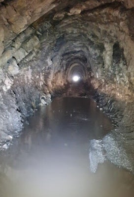
There is always water in the tunnel of the Col du Parpaillon, except when it freezes , see my video from early July. Take a torch with you, because there are no lights. The road inside is very bumpy, full of potholes and stones, hidden in the cold mirky water.
Dry socks can be nice during the decent; don't fall into the water, you might need more than socks. Your phone is not working here, if you need help; you can only use it as a torch (don't drop it in the water). Maybe you can find another fool who wants to prove he or she is a man. There is strength in numbers and sometimes (s)he can make a short video.
Ask at the Tourist Office if the tunnel is open, it is disappointing when the doors are closed.
Use an All Terrain Bike or gravel racer, not your time-trial bike. https://en.wikipedia.org/wiki/Col_du_Parpaillon
More: Barcelonette, Cime de la Bonette , Saint-Delmas-le-Selvage, Col de la Moutière, Barcelonette 86km.

We are on the Cime de la Bonette (2802m), an artillery post; it is the highest paved road in the French Alps. The Col de la Bonette (7) is lower at 2715m.
Google Maps will show you around:
https://www.google.nl/maps/@44.3946146,6.6318292,11z?entry=ttu

A very nice ride, is combining the Col de la Cayolle (1), the Col des Champs and the Col d'Allos (2); in total 120km and 3340m elevation gain.